
As reported by Reuters, Israel quietly issued new maps of Gaza showing an expanded restricted area that, together with the existing Yellow Line, places nearly two-thirds of Gaza under Israeli military control. The maps were shared with aid groups in Gaza in mid-March, according to aid sources cited in the reporting, but were not publicly released by the military.
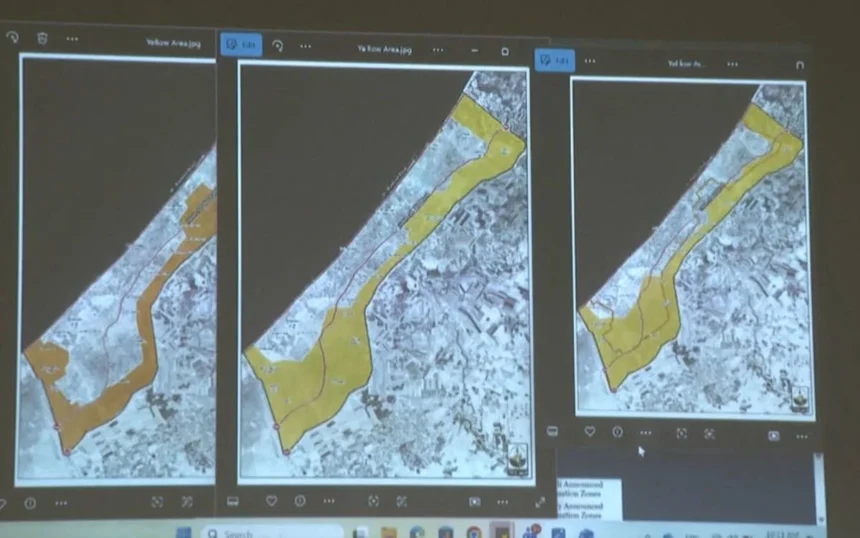
According to the reporting, the newly marked restricted area is shown with an orange line and is estimated to cover about 11% of Gaza’s total territory beyond the Yellow Line. The Yellow Line refers to the area occupied by Israeli troops since the October ceasefire.
What the maps show
Reuters reported that the updated maps appear to shift the boundaries of the restricted zone, affecting thousands of displaced Palestinians. The military said the area can continue to be adjusted, and aid movements there must be coordinated with Israeli forces.
The reporting said the expanded zone has raised concern among Palestinians who fear the area could be treated as a target zone or become a permanent hold. Israel has described such areas as buffer zones intended to reduce the risk of militant attacks.
What are aid groups saying?
According to the reported accounts from two aid sources working in Gaza, the Israeli military first sent aid groups a map showing a restricted zone after the October ceasefire, and later sent an updated version in mid-March. The sources said the new map was shared with them but not published directly by the military.
Reuters said the earlier map had been circulated by organizations including UNICEF. The military’s position, as reflected in the reporting, is that civilians are not affected and that the zone is meant to facilitate aid delivery.
Why does this matter?
The reported expansion of military control has significant implications for displaced civilians, humanitarian access, and post-ceasefire territorial boundaries in Gaza. If the map’s lines are maintained or widened further, it could affect where aid groups can operate and where civilians can safely remain.
The reporting suggests that the control lines are not fixed, which adds uncertainty for residents and relief organizations. That uncertainty is now central to the wider debate over Gaza’s future territorial and humanitarian conditions.
The confirmed development is that Israel’s newly issued maps indicate a much larger restricted zone inside Gaza, and the reported effect is control over nearly two-thirds of the territory. The military has said the boundaries may still change, while aid groups and displaced Palestinians face the immediate consequences of those shifting lines.