
The Gaza Strip is a small, densely populated coastal territory at the heart of one of the world’s most protracted political conflicts, yet it also has a deep historical and geographic significance that long predates the modern era. Understanding its location, people, and past is essential to making sense of current events while still appreciating its enduring role in regional history.
- Where the Gaza Strip Is and Why It Matters
- Population, Society, and Demographics
- A Deep Historical Background
- From Mandate to Division of the Land
- Autonomy, Administration, and Political Fragmentation
- Geography, Land, and Environment
- Economy, Livelihoods, and Structural Constraints
- Humanitarian Conditions and International Attention
- Culture, Identity, and Daily Life
- Gaza Strip on the Map: Borders and Crossings
- International Law, Status, and Diplomacy
- Long-Term Challenges and Prospects
- Conclusion
Where the Gaza Strip Is and Why It Matters
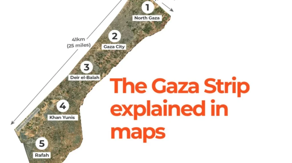
The Gaza Strip is a narrow piece of land on the southeastern coast of the Mediterranean Sea, bordered by Israel to the north and east and Egypt to the southwest. Covering roughly 365 square kilometers, it is often described as being about twice the size of Washington, D.C., making it small in area but extraordinarily significant in geopolitical terms.
Its coastline along the Mediterranean has historically made Gaza a gateway between Africa and Asia, sitting on trade routes that connected Egypt, the Levant, and beyond. This position helped the city of Gaza develop as a trading and administrative center over many centuries, long before today’s political borders were drawn.
Population, Society, and Demographics
The Gaza Strip is one of the most densely populated territories in the world, with well over 2 million residents living within its limited area. A significant share of the population is made up of Palestinian refugees and their descendants who were displaced from other parts of historical Palestine during the mid‑20th century.
Gaza’s population is notably young, with nearly half of residents under the age of 18 according to United Nations assessments. This youthful demographic profile creates both potential and pressure: it indicates a large future workforce, but also translates into high demand for education, jobs, housing, and basic services.
Poverty and unemployment have been persistent features of life in Gaza, with UN sources indicating that a large share of households live below the poverty line and depend on humanitarian assistance for essential needs. Food insecurity affects more than half of residents, and many families rely on aid agencies for regular food supplies, healthcare, and social support.
A Deep Historical Background
The area that is now the Gaza Strip has been inhabited for thousands of years and has been mentioned in historical sources dating back to the second millennium BCE. Over time, it has come under the rule of various powers, including ancient Egyptian, Philistine, Persian, Hellenistic, Roman, Byzantine, and early Islamic empires.
Under Ottoman rule, which lasted for several centuries until the early 20th century, Gaza functioned as a regional town within a broader provincial framework of greater Syria and Palestine. The local population during this period consisted mainly of Muslim and Christian Arabs, with Gaza linked economically and socially to surrounding cities and rural areas.
Following the First World War, the Ottoman Empire’s territories in the region were placed under British administration as part of the Mandate for Palestine. During the British Mandate period, political activism and an emerging Palestinian national identity became more pronounced in towns such as Gaza, especially as tensions grew around land, immigration, and self-determination.
From Mandate to Division of the Land
The modern territorial shape of the Gaza Strip is closely tied to the mid‑20th century reordering of the region. After the end of the British Mandate and the 1948 Arab–Israeli war, the area that is now Gaza came under Egyptian military administration. Hundreds of thousands of Palestinians displaced from other parts of the former Mandate territory sought refuge there, which dramatically changed the demographic and social landscape.
The armistice lines drawn after the conflict effectively defined the boundaries of the Gaza Strip as a narrow enclave along the coast. Large refugee camps were established and gradually grew into dense neighborhoods, setting patterns of crowding and limited land availability that still influence daily life.
In 1967, during another regional war, Israel occupied the Gaza Strip along with the West Bank and other territories. Over subsequent decades, Israeli authorities maintained military control, established settlements within Gaza, and regulated movement and economic activity, further entangling the territory in broader regional dynamics.
Autonomy, Administration, and Political Fragmentation
The late 20th century saw efforts to create a framework for Palestinian self-governance, which included the Gaza Strip as a core component. The Oslo Accords in the 1990s led to the establishment of the Palestinian Authority and a partial transfer of administrative responsibilities in Gaza and parts of the West Bank. This period raised expectations that the territory might evolve toward greater autonomy and development under a negotiated political process.
In 2005, Israel withdrew its settlers and permanent military installations from inside the Gaza Strip while maintaining control over its airspace, territorial waters, and most of its border crossings. The internal Palestinian political landscape changed significantly in the subsequent years, with different factions competing for control and resulting in a separate administration operating in Gaza compared with the Palestinian Authority based in the West Bank.
These political divisions have complicated governance, economic planning, and reconstruction efforts and have made it more difficult to coordinate responses to social and humanitarian needs across the Palestinian territories. Despite this, local institutions, civil society organizations, and international agencies continue to operate schools, clinics, municipal services, and social programs in the Strip.
Geography, Land, and Environment
Although small, the Gaza Strip has varied land uses, including urban centers, refugee camps, agricultural fields, and coastal areas. The main urban core is the city of Gaza itself, surrounded by other towns and camps that, over time, have expanded and merged into a continuous built‑up strip along much of the territory.
Agriculture traditionally played an important role in Gaza’s economy, with farmland used to cultivate crops such as olives, citrus fruits, vegetables, and flowers. However, access restrictions along land borders and in designated security zones have reduced the area available for agriculture, limiting farmers’ ability to reach their fields and market their produce.
Environmental pressures are severe. Water scarcity is a chronic challenge, as the territory relies heavily on a coastal aquifer that is stressed by over‑extraction and contamination. Poor wastewater treatment infrastructure has led to partially treated sewage being discharged into the sea, affecting marine ecosystems and coastal water quality. These pressures underscore the link between environmental management, public health, and long‑term sustainability.
Economy, Livelihoods, and Structural Constraints
The Gaza Strip’s economy has long been constrained by its small size, limited natural resources, and restricted access to regional and global markets. United Nations and development‑agency assessments emphasize high levels of unemployment and underemployment, especially among youth, as a defining feature of the local labor market.
Many households rely on a mix of informal work, small-scale commerce, public sector salaries, and international assistance to make ends meet. Access restrictions on the movement of people and goods—both within the Palestinian territories and across external borders—have limited private investment, industrial activity, and opportunities for trade.
International financial institutions have noted that these constraints have severely weakened Gaza’s contribution to the overall Palestinian economy. Economic contractions linked to episodes of conflict and closure have caused sharp declines in output and income, making recovery difficult and leaving the territory dependent on external support for reconstruction and basic services.
Humanitarian Conditions and International Attention
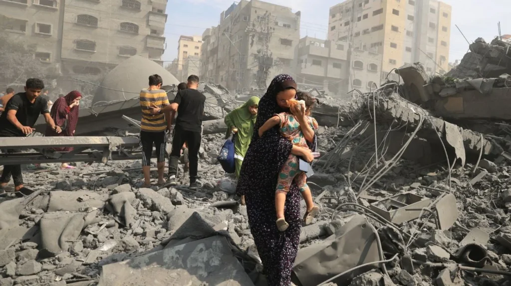
Humanitarian conditions in the Gaza Strip have been the subject of sustained concern from the United Nations and numerous international organizations. These agencies document high levels of poverty, food insecurity, and aid dependency, alongside challenges in health, education, and shelter.
Movement restrictions have created what humanitarian reports describe as a situation of isolation, with most residents unable to move freely to other parts of the occupied Palestinian territory or abroad. This isolation affects access to specialized medical care, higher education opportunities, professional exchanges, and family reunification.
At the same time, international actors, including UN agencies, development banks, and non‑governmental organizations, have provided ongoing assistance in areas such as health services, schooling, emergency relief, and infrastructure rehabilitation. Their reports highlight the importance of predictable access for humanitarian and development operations to address immediate needs while supporting longer-term resilience.
Culture, Identity, and Daily Life
Despite the constraints and hardships, the Gaza Strip is home to a vibrant society with a rich cultural life rooted in Palestinian traditions. Families and communities maintain social networks that extend across neighborhoods, camps, and villages, reinforcing a strong sense of identity and belonging.
Local culture includes traditional music, poetry, cuisine, and handicrafts, as well as contemporary art, literature, and media produced by young and established creators. Educational institutions and community centers serve as venues for cultural expression, dialogue, and learning, even under conditions of uncertainty.
Daily life for residents involves balancing ordinary routines—such as schooling, work, family gatherings, and religious observance—with the disruptions created by economic pressures and security concerns. This mix of resilience and strain shapes how people in Gaza experience their homes, neighborhoods, and public spaces.
Gaza Strip on the Map: Borders and Crossings
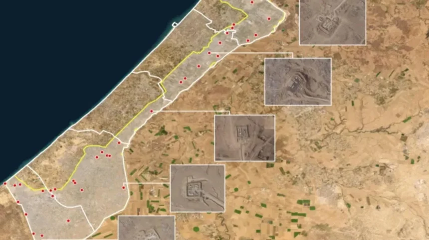
On a map, the Gaza Strip appears as a slender rectangle hugging the Mediterranean coast, with a land border of roughly 50 kilometers. It shares a short border with Egypt at Rafah in the south and a longer border with Israel along its northern and eastern edges.
Border crossings are critical to the territory’s connection with the outside world, as they regulate the flow of people, goods, and humanitarian supplies. The functioning of these crossings, including the movement of construction materials, fuel, medical equipment, and food, has a direct impact on living standards and the capacity for rebuilding infrastructure.
Coastal access is another key component of the Strip’s geography. Fishing has traditionally been a source of livelihood for many families, but access to fishing waters is often limited by security regulations and maritime restrictions. These constraints affect both income and food availability, illustrating how geographic features and policy decisions intersect in everyday economic life.
International Law, Status, and Diplomacy
The status of the Gaza Strip is widely discussed in the context of international law and diplomacy relating to the Israeli–Palestinian conflict. Most international bodies consider the Strip part of the occupied Palestinian territory, along with the West Bank, and address it in resolutions, reports, and negotiations on that basis.
United Nations agencies and other international actors frame their work in Gaza in terms of humanitarian principles, human rights, and development goals. Their analyses often emphasize that sustainable improvements in living conditions depend on broader political arrangements that address security, freedom of movement, and economic access.
Diplomatic efforts over the years have tried to link local conditions in Gaza with regional and international initiatives aimed at conflict resolution and state‑building. While outcomes have been limited, these processes highlight the territory’s centrality to any comprehensive peace framework.
Long-Term Challenges and Prospects
Looking ahead, the Gaza Strip faces a set of intertwined challenges: demographic growth, economic stagnation, environmental stress, and political uncertainty. Population density continues to increase, putting pressure on housing, public services, and infrastructure such as water, electricity, and sanitation systems.
Development organizations emphasize that lasting progress requires both improved local governance and changes in the broader context, including eased restrictions on movement and trade. Enhancing human capital—through quality education, vocational training, and health care—is often cited as essential for any future economy that can provide dignified livelihoods.
At the same time, the territory’s historical position as a crossroads, its educated youthful population, and its coastline offer potential foundations for future recovery and growth if conditions allow. The way these factors are managed will shape whether the Strip can transition from chronic crisis toward a more stable and sustainable trajectory.
Conclusion
The Gaza Strip is far more than a news headline; it is a densely populated coastal territory with deep historical roots, a complex political status, and a society striving to maintain daily life under exceptional constraints. Its geography, demographics, economy, and humanitarian situation are all interconnected, and any long‑term improvement depends on addressing these elements together rather than in isolation.
For anyone seeking to understand the modern Middle East, a clear grasp of the Gaza Strip’s location, history, and living conditions is indispensable. Its future will continue to be shaped by local resilience, regional dynamics, and international engagement, making it a focal point of both challenge and potential in the wider region.
